
Spatial-Temporal Variation Characteristics and Cause Analysis of Water Quality in Yinma River Basin
2022-06-01 12:39:24XiaolaiWUJingWANGShukunJIANGLeiXUXiangzheMENG
Asian Agricultural Research 2022年4期
Xiaolai WU, Jing WANG, Shukun JIANG, Lei XU, Xiangzhe MENG
1.Jilin Provincial Hydrology and Water Resources Bureau/Jilin Provincial Water Environment Monitoring Center, Changchun 130022, China; 2.Heilongjiang Key Laboratory of Geographical Environment Monitoring and Spatial Information Service in Cold Region, Harbin Normal University, Harbin 150025, China
Abstract In order to comprehensively understand the water quality in Yinma River Basin, and to analyze the spatial-temporal variation characteristics of water quality over the years and the causes of water pollution, 15 sections were selected in the Yinma River Basin.Based on the water quality monitoring data in the past decade, 7 evaluation indexes including dissolved oxygen(DO), 5-day biochemical oxygen demand(BOD5), permanganate index(CODMN), chemical oxygen demand(COD), ammonia nitrogen(NH4-N), total phosphorus(TP)and total nitrogen(TN)were determined, according to the Environmental Quality Standard for Surface Water(GB3838-2002)and the historical monitoring data of rivers.The water quality of 15 sections in Yinma River Basin was comprehensively evaluated, and the water quality categories and the evolution of river water quality were analyzed.The pollution sources of Yinma River Basin were analyzed, and the constructive countermeasures were put forward according to the conclusions.
Key words Yinma River, Water quality, Characteristic, Cause analysis
1 Introduction
Yinma River is a primary tributary of the second Songhua River, originating in the southeast side of Laoyeling along Hadaling Mountain in Yitong County.It falls into Yitong River in Kaoshan Town, Nong’an County, and flows into Songhua River in the southeast of Hongshileitun in Kaoshan Town.The river is 386.80 km long, with a drainage area of 17 400 km2(including the Yitong River with an area of 9 300 km2).Tributaries of Yinma River Basin with an area of more than 1 000 km2include Shuangyang River, Chalu River, Wukai River and Yitong River[1].
2 Evaluation of water quality in Yinma River Basin
2.1 Water quality monitoring and evaluation methods
2.1.1Implementation standard of water quality monitoring.The surface water testing method in theSurfaceWaterEnvironmentalQualityStandard(GB2828-2002)was adopted, and the specific testing standard is shown in Table 1.
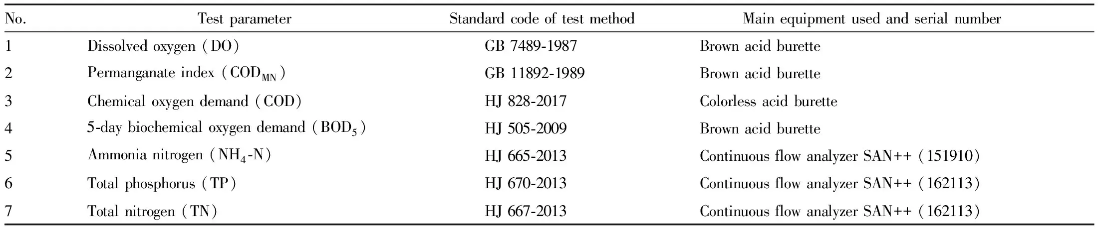
Table 1 Main testing items and methods mg/L
2.1.2Water quality evaluation method.The pollutant overproof value, the water quality grading standard and the contribution of pollutants to the total pollution are linked by fuzzy comprehensive evaluation method.The specific steps are as follows.
(i)Establish evaluation object setU={u1,u2,u3, …,u}.In this study,u={DO, BOD5, CODMN, COD, NH4-N, TP, TN}.
(ii)Establish water quality evaluation grades.The water quality evaluation grade isL={I, II, III, IV, V}.
(iii)Establish membership function.
(iv)Establish fuzzy matrix.Through the membership function, the membership relationship of theithsingle index to thejthgrade water quality is calculated by the measured value, and the matrix is obtained.
(v)Establish weight matrix.A={a1,a2,a3, …,an}
(vi)Calculate evaluation results.
W=A×R.
2.2 Evaluation of water quality in Yinma River BasinFifteen monitoring sections were selected from Yinma River Basin for evaluation[2].The perennial water quality of the three sections of Shitoukoumen Reservoir was evaluated as grade III, and the perennial water quality of the other three monitoring sections was inferior grade V.The superstandard multiple of pollutants in Changling section successively were NH4-N >TP>BOD5>COD>CODMN.In 2009, NH4-N, TP and BOD5exceeded the standard by 9.9, 3.6 and 0.6 times, while in 2013, NH4-N, TP and CODMNexceeded the standard by 8.3, 2.2 and 0.1 times, respectively.In 2018, NH4-N, TP and CODMNexceeded the standard by 6.7, 2.3 and 0.5 times, respectively.In general, although the superstandard multiple of pollutants had decreased, there was no change in indicators of pollutants in different years, and there was generally no significant change in water quality in this section[3].The perennial water quality of Latapao section was inferior grade V, and the superstandard multiple of pollutants successively were NH4-N>BOD5>COD>CODMN.In 2009, NH4-N, BOD5and COD exceeded the standard by 5.8, 0.8 and 0.1 times, while in 2013, NH4-N, BOD5and COD exceeded the standard by 0.5, 0.7 and 0.2 times, respectively.In 2018, NH4-N, BOD5and COD exceeded the standard by 0.5, 0.6 and 0.5 times, respectively.The pollution of indicators in this section was particularly stable, indicating that the surrounding conditions of the basin were stable, and the pollutant concentration had reduced, suggesting that the water quality changed in a better direction.Dehui section is the control section where Yinma River flows into the Second Songhua River, and its perennial water quality was inferior grade V.The superstandard multiple of pollutants successively were NH4-N>BOD5>COD>TP.When analyzing this section, it was found that although the source of pollutants was stable, the NH4-N indicator showed a turning point.It exceeded the standard by 7.5 times in 2009, which lowered to 1.7 times in 2015, and increased to 5.1 times in 2018, while the water quality was still inferior grade V.Although the other three sections, except the drinking water source control section, were stably controlled in the inferior grade V, it is found that most of the superstandard multiples were slowly decreasing year by year, indicating that the water quality of Yinma River was improving year by year.
3 Analysis of pollution sources in Yinma River Basin
3.1 Research methodsAccording to the water quality sections designed along Yinma River Basin, 15 monitoring points were analyzed throughout 2018.Two Landsat8 image data with a resolution of 30 m in Yinma River Basin in May and September 2018 were selected.Based on geometric correction and atmospheric correction, supervised classification was adopted to extract land use information in the area[4].According to the classification standard ofTechnicalSpecificationforEcologicalandEnvironmentalStatusAssessment(HJ192-2015), 7 land cover types including cultivated land, grassland, vegetable land, forest land, urban land, bare land and water body were selected as research objects.Combined with DEM and drainage system distribution, the data of land use types in 7 catchment units were obtained.The industrial proportion, per capita GDP, population density and other data were derived from theStatisticalYearbookofJilinProvinceandChangchunStatisticalYearbookin 2017.A Pearson analysis of water quality and land use in Yinma River Basin was conducted by SPSS 17.0 software[5].
3.2 Relationship between land use and river water quality in Yinma River BasinThe extracted land use information map(Fig.1)was divided according to their functions, and the research area was divided into 7 catchment areas.As shown in Fig.1, the urban land area of A2 accounted for 52%-58% of the total area; the cultivated land area and forest land area accounted for 18%-20% of the total area; and the cultivated land area of A1 and A5 accounted for 48%-56% of the total area.Generally speaking, the cultivated land area from A1 to A7 accounted for a large proportion.However, the forest land area from A1 to A7 also remained at about 19%, and the proportion of vegetable land and bare land was relatively small.There was a large difference in the proportion of land use type area in the 7 areas.
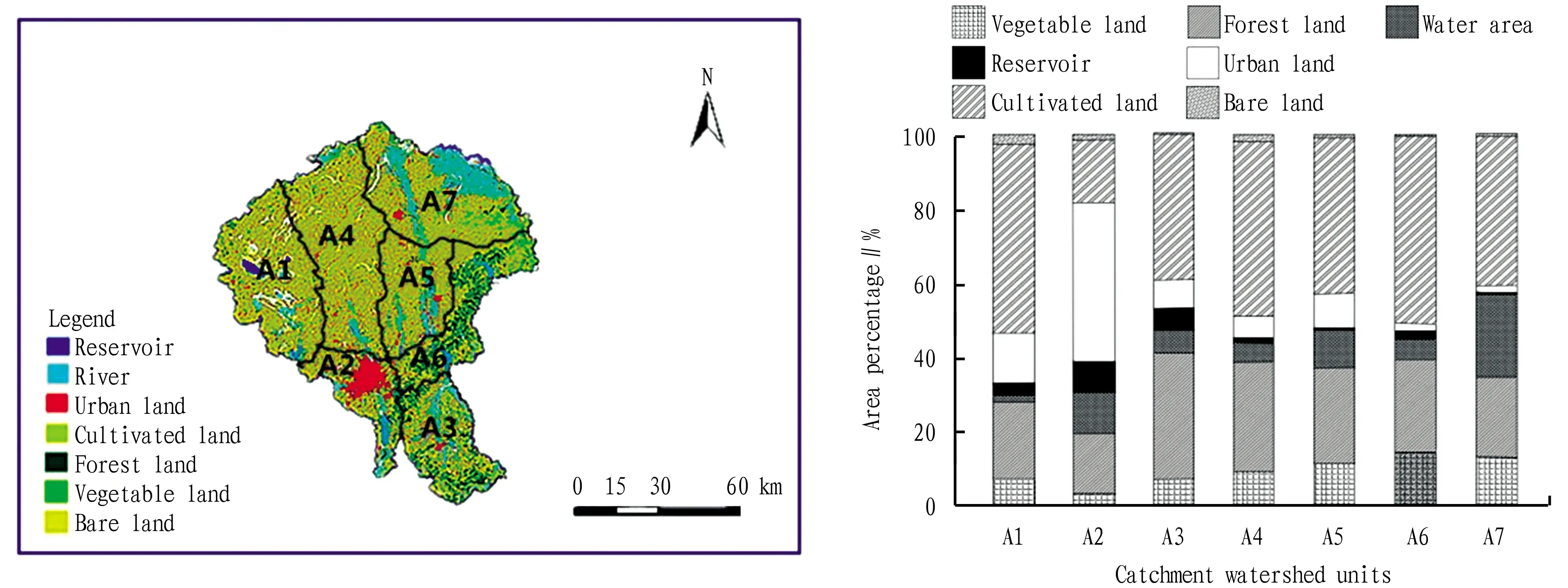
Fig.1 Land use type and area ratio in Yinma River Basin
As shown in Table 2, the area proportion of land use type had different correlation with the water quality of the basin in which it was located.The results showed that urban land use was negatively correlated with DO, which indicated that the impact of urban production and domestic sewage on dissolved oxygen indicator was reflected in the increase of oxygen demanding substances in water after the discharge of urban pollutants, thus reflecting the low measured value of DO[6].There was significant positive correlation between COD and urban land area, indicating that domestic wastewater produced by urban land use and wastewater produced by urban processing and production would significantly increase water pollution.TP was positively correlated with cultivated land, bare land and vegetable land, indicating that agricultural cultivation and soil leaching would increase the concentration of phosphorus related substances in water.Meantime, TN was significantly positively correlated with cultivated land, bare land and vegetable land, indicating that agricultural cultivation methods, excessive use of pesticides and fertilizers, and agricultural planting types all led to the increase of TP and TN concentrations in water bodies.After pollutants enter the water body, it will easily cause eutrophication of water body, and the aggravation of eutrophication of water body is easy to induce the outbreak of blue-green algae.In 2007, the blue-green algae outbreak in Xinlicheng Reservoir caused water suspension for 45 d, which brought great inconvenience to residents and caused serious economic losses.
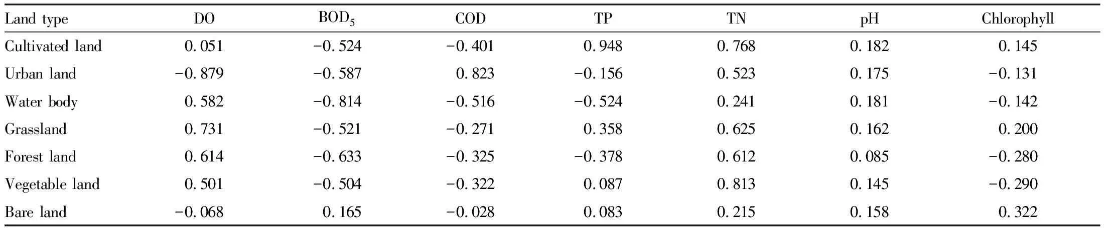
Table 2 Correlation between land use pattern and water environment index in 2018
4 Conclusions and suggestions
The water quality of Yinma River Basin is improving year by year.However, as this basin is the main grain crop growing area in Jilin Province, its pollution is mainly affected by non-point source pollution, with great seasonal effect.Therefore, it is necessary to strengthen the development of agricultural green industry and strengthen the construction of ideology, so as to gradually restore green hills and clear waters.In order to improve the water quality in Yinma River Basin, we should strengthen the control of non-point source pollution and improve the legal system, accelerate the process of agricultural science and technology, develop green agriculture, and carry out special treatment measures in key areas.
 Asian Agricultural Research2022年4期
- Asian Agricultural Research的其它文章
- Analysis on the Experimental Teaching Reform of Landscape Design under the New Situation
- Research and Practice on Curriculum Reform of Chinese Pharmaceutical Manufacturing Major against the Backdrop of "Comprehensive Health"
- Development Status and Strategies of Xieka Cattle
- Study on Improvement of Soil Porosity
- Optimization of Making Process for Whole Fish Frying Using a Universal Oven
- Effects of Different Nitrogen Levels on Growth and Nitrogen Utilization of Sugarcane