Urban Green Space Planning Method Based on Low Impact Development: Research on Planning Mechanism under Digital Landscape Technology
2019-01-13 10:20:32CHENGYuningHOUQingheXIEMingkun
中國(guó)園林 2019年10期
CHENG Yuning, HOU Qinghe, XIE Mingkun
1 Interpretation of Low Impact Development
1.1 Scientific connotation of low impact development
The concept of Low Impact Development(LID), which is a kind of rainwater management approach that can realize rainwater control and utilization, was first put forward in 1977 in Vermont,America in its ecological land use planning. Along with the proposal of the strategies such as Sponge City, Ecological Restoration and Urban Renovation,and Park City in China, LID is starting to extend and stretch towards the directions including urban ecosystem conservation and restoration, ecological planning, rainwater control and utilization, and a set of entirely new theories and methods which take aquatic environmental science, landscape architecture and ecology as the main framework is gradually developing and forming, of which the core mainly includes: 1) reducing energy consumption and resource consumption and realizing sustainable development of the city by simulating natural process and systematically interpreting the urban ecosystem operation rules as well as the correlation with objective environment and human activities on the basis of the framework of ecology principle; 2) conducting planning &design by simulating nature based on the natural characteristic of the site and minimizing the adverse impact of artificial construction under the guidance of the theory of environmental disciplines while following the law of nature; 3) carrying out incremental land low-impact development and construction systematically in good order in accordance with local conditions as well as changing circumstances.
1.2 Relativity of low impact development
The urban ecosystem includes not only the about 30%~40% of land which is of "natural character" covering natural mountain, forest and water system, but also the 60%~70% of the artificially built environment. The relativity of LID is reflected in its research objects. On one hand, it's an urban natural environment, and on the other hand, it's an urban built environment, covering not only "new town" but also "old town". Compared with the new town which focuses on protective planning & design of the existing environment, the old town also faces the problem of LID in respect of micro renewal. As a step-by-step process, its principle is a restoration and renovation process of micro renewal and micro transformation of the built environment.
1.3 Water & green space relationship in the built environment
Natural ecosystem and artificial ecosystem together constitute an urban built environment,of which an artificial ecosystem is a kind of natural ecosystem simulating nature and has the basic characteristic of simulating natural life process and function. With a variety of ecological service functions such as rainwater detention storage, purification and osmosis, urban green space is not only the best medium to realize urban water environment optimization, but also an important part of constituting urban sponge body. Establishment of the ecological relationship of commensalism between urban water & green space refers to multi-level water & green space blending which realizes overall spatial arrangement from single scale and composition structure by coordinating the relationship and function mechanism from element to system between urban water & green space based on the basic principle of "water & green space coupling".
2 Planning Theory of Water & Green Space Coupling
2.1 Target of water & green space coupling
"Coupling" is a basic conception of physics,which refers to a kind of phenomenon that two or more systems or processes connect with each other through the impact on each other from various interactions. Water & green space coupling principle defines the dynamic relationship between water & green space from the scale of element and composition structure to overall spatial arrangement according to the function mechanism of green land in urban hydrologic cycle system,including the coupling target in 3 aspects of water& green space scale, composition structure and spatial arrangement.
2.2 Water & green space scale coupling
Establishing a water & green space scale coupling mode, adopting scientific calculation and analysis of water & green space scale, and adjusting green land scale and LID measures by dividing rainwater sub-region can help achieve dynamic association and balance between urban green land (including various low impact technical measures in urban green land) detention storage water volume and urban green land water consumption, and facilitate the resource utilization of rainwater and sustainable development of urban green land.
2.3 Composition structure coupling
Under the concept of LID, green land, water body, and LID measures together constitute the carrier of urban rainwater regulation and storage,and different composition structures of underlying surface also cause different sponge effects. Under the realistic condition of scarcity of urban built environment and land resource, scientific and reasonable LID of green land to constitute the configuration of structure can generate a green land composition structure on the basis of water &green space scale coupling.
2.4 Spatial arrangement coupling
From the perspective of LID, common-weal green land layout can better realize rainwater source control and local consumption, as well as reduce overland runoff and facilitate rainwater control and utilization at the same time. Under the premise of constant greening rate, adjusting the spatial arrangement of green land, water body and LID measures according to the spatial distribution of urban hydrology can better realize the comprehensive hydrological effect of urban green land.
3 Planning Method of Water & Green Space Coupling under the Assistance of Digital Technology
The planning method of water & green space coupling under the assistance of digital technology is established by means of scientifically choosing corresponding digital technology and platform and then integrating them into various links of the planning process of water & green space coupling based on the urban green land planning target of water & green space coupling.
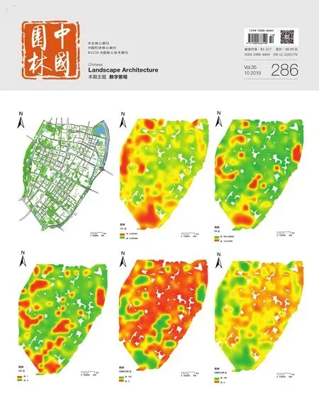
3.1 Urban rainfall-spatial distribution of runoff yield and concentration and scheme performance simulation
Urban rainfall-runoff yield and concentration simulation is a process of mainly applying the hydrological model to generalize the spatial and temporal distribution phenomenon and process of complex rainfall-runoff to be an approximate scientific model, and then simulating the water yield as well as water quality change of a particular rainfall or during a long-term rainfall process of urban area.Common hydrological model includes the lumped hydrological model and distributed hydrological model, of which the latter adopts a strict mathematical physical equation to express all subprocedures of the hydrological cycle. Quantitative hydrological simulation can cover the whole process of green space planning, including pre-evaluation in the earlier stage, scheme simulation in the middle stage, and scheme performance simulation in the later stage.
3.2 Analysis of urban water & green space structure relationship and function mechanism
Landscape pattern mainly refers to the spatial pattern of landscape, which means the spatial structure feature of a series of landscape elements of different sizes, shapes, and types in a certain time and space. It's not only the concrete embodiment of landscape heterogeneity, but also the results from the effects of various ecological processes in different scales. The analysis of urban green land structure relationship and function mechanism is applying landscape index method and spatial statistics method to analyze green land landscape pattern on the basis of landscape pattern analysis method, and then discovering potential green land structure feature and its distribution rule in the complex and seemingly disordered urban system.
3.3 Digitization generation of urban green land pattern based on algorithm model
Digitization generation of urban green land pattern means to generate a wide range of green land pattern schemes which can realize set target mainly by establishing the algorithm model for site selection of green land, setting prospective model operation target, and regarding green land pattern index which can effectively produce hydrological effect (potential factor) and restricted condition in current situation (restriction factor) as the rule of model operation while taking advantages of site location algorithm model and machine learning.
3.4 Performance simulation and multi-plan comparison & selection of water & green space coupling through double-platform checking
In order to avoid accidental error due to a single platform and probable impact of parameter setting of model on simulated result, it's necessary to establish a scientific double-platform checking technology to conduct checking and calibration of relevant parameters and make cross-checking and comparison of the simulated results of the doubleplatform by relying on the operation principle and consistency of parameter setting of doubleplatform, and then choose the optimal green space planning scheme with high degree of water &green space coupling from numerous results after comparison of scheme simulation.
4 Practice of Green Space Planning under the Guidance of Digital Technology
Under the assistance of digital technology,LID green space planning adopts the ideas of"hydrological analysis, structural simulation, layout planning, scheme checking", and the same method is separately applied in the practice of green space planning of LID under different conditions of three kinds of scales including urban whole region, urban area, and urban block.
5 Conclusion
The purpose of Low Impact Development is to help urban catchment area have the operation effect of simulating natural hydrologic cycle,integrate the water storage function of green land under the current spatial structure of urban green land, and realize the target of Low Impact Development. Urban green space planning is not restricted to the simple emphasis on the pattern of point, line, and plane anymore. Instead, it should pay more attention to the natural process as well as optimization of the internal ecosystem while satisfying urban green land function in traditional sense to ensure the scientificity of urban green space planning by relying on digital landscape technology and through quantitative analysis,model and simulation.